A section of the east ridge on the Kleiner Nesthorn collapsed on Monday evening, according to the Walliser Bote newspaper. For the first time, debris flowed down the Birch Glacier, sweeping away glacial debris.
Was not as bad as predicted though. It’s been in the news for the last couple of days.
Boooooh for the click bait title…
2 Likes
When this forum turned into Daily Mail? ![]()
2 Likes
An English friendly summary via the Landslide Blog:
Der Argauer Zeitung has live coverage for free: Blatten: Der Liveticker zum möglichen Bergrutsch
In the geological spatial scale, nothing is small…a big chunk mountain is moving. The landslide is nothing compared to the section of the mountain that fractured. Also, put on your headphones and listen to the mountain:
Well they are expecting a huge amount and the town has been evacuated!
What they hope for now is that it all happens slowly, bit by bit and therefore causes less damage.
Actually - as to click baiting - it also crossed my mind we will look like the Nederlands some day, if we carry on like this here.
1 Like
Rock fell on top The Birch Glacier, the extra weight is making the glacier move between 2.5 to 3.5 meters per day. Slower than a snail but in the geologic scale, it’s scary. Just for reference, the glacier was moving at 0.5 to 0.8 m/day last Wednesday May 21.
This photo in blick today shows a big rock in cantilever/overhang and rocks are not good at resisting tensile stress…so, there’s still rocks pending to fall.

1 Like
Well what goes up must come down. Unless of course it goes too far up.
ha.
Update via 20min. Glacier is moving at 10 m/day (!), but the avalanches triggered by the glacier collapse have not been large enough to reach the village.
The village is lucky, the mountain falls piece by piece instead of all at once…so far.
2 Likes
The risk for Blatten has been identified before. Actions were taken, a protection dam (Schutzdamm) was built. This structure similar to a dam or a dike is clearly seen on satellite images. About 10-15m wide, 270m long and it should be 5-10m high.
This morning 20min shared a photo that all the material coming down in the last days has been accumulating in the ravine. The first avalanche has gone over the protection dam. Also, blick reports that avalanche debris has reached the river in the valley (Lonza river). A blocked river is not a good thing.
Avalanche debris should be reaching the village sooner than later. No one knows if there will be a huge avalanche or hundreds of small ones. The small ones might bury the village slowly, layer by layer of debris.

Good engineering and civil protection keep people safe. But, there are limits.
The glacier is moving too. It’s bound to melt, has anybody mentioned where all this water is gonna go and with what effect?
The white material in the last photo is ice from the glacier mixed with rocks. If it weren’t for the interaction of the fallen rocks and the glacier, this story should have ened
Short-term: melting is a slow process, flooding should not be a major issue. The river flow rate will just be higher than average but not catastrophic.
Long-term: glaciers are water reservoirs. With this glacier gone, the river will have a lower average flow rate in the future. How much lower? No idea.
Terradata, a Swiss company specialized in geomeasurements, has made public the topo data gathered from a helicopter flight above the landslide on 23.05.2025. The scale of the landslide is astonishing.
lInkedin post: Virtueller Flug Bergsturz Kleines Nesthorn, Daten vom 23.05.2025 | Terradata
The 3D model KLNBIL - 3D model by Terradata AG (@TEDA) [0d10965] - Sketchfab
2 Likes
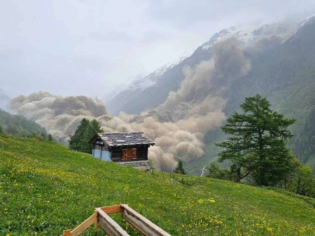
And…something happened at 15h30, who knows what’s inside the dust cloud:
The Swiss Seismological Service recorded something equivalent to a magnitude 3.1 earthquake at 15h24m38s on that mountain:
1 Like
Good news: evacuation was complete. Bravo for civil protection and all the people involved in the forecast.
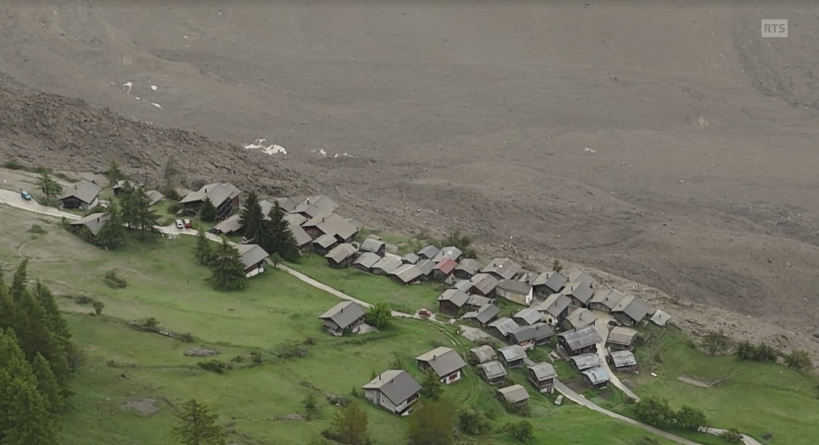
Not so good news: the avalanche went up the slope of the mountain on the other side of the valley. The village is probably gone. A quick guess, this pic is taken 20-30m above the valley bottom.
There’s also a huge dam blocking the river. The river needs to be unblocked, but not possible to work there before assessing the possibility of further avalanches. Depending on the weather in the following days (rainfall), this might be the end of the nightmare or…a cantonal crisis.
PS. this new natural dam is upstream of the south portal of the Lötschberg rail tunnel.

Terrible news, even if we all knew there was something coming.
Terrible for the people there, for nature and for the mountains.
As a teen ager I lived in the mountains, I climbed them and I walked up them for hours on end with furs on my skis to enjoy skiing in deep, fresh, untouched snow.
When the mountains aren’s the rock in my sea anymore, what is?
3 Likes
One person is missing and many houses have been destroyed.
1 Like
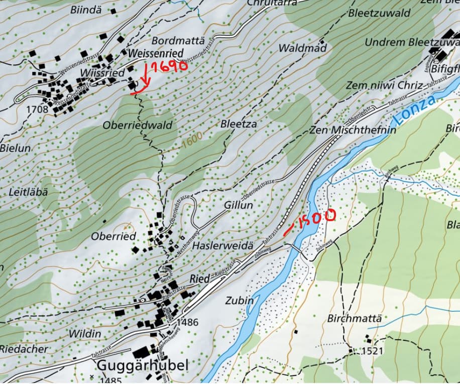
Absolutely insane. RTS is sharing this preliminary map of the area covered by debris.

Approx 2/3 of Blatten is gone. Ried is 100% covered by debris.
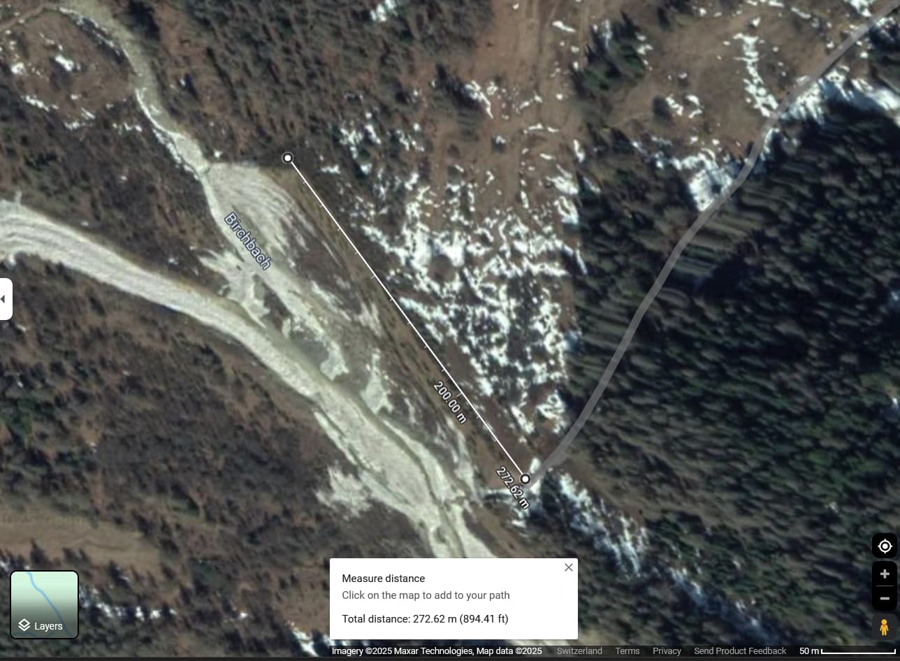
However, what is hard to believe (and probably related to person missing) is the debris almost reaching the village of Weissenried. Weissenried is about 1’708 meters above sea level. The lowest house in Weissenried is about 1’690 meters above sea level. Also from RTS, this is how close the avalanche got to the village.
The river Lonza is about 1’500 meters above sea level. It’s almost impossible to foresee that an avalanche happening in the mountain on the other side of the valley will climb up 200m on the mountain in front. Looking at the topo in detail…no f******* way!
4 Likes
Crazy.